Electronics & Semiconductor
Tariff Shocks Meet Underground Asset Density: Deliverable Growth and Supply-Chain Reconfiguration in the Global GPR Market (2025–2032)
18 December 2025
According to APO Research’s latest 2026 report, Ground Penetrating Radar (GPR) is a non-destructive subsurface sensing technology that uses short-duration, high-frequency electromagnetic pulses to image near-surface structures by transmitting energy into a material and recording the time, amplitude, and phase characteristics of reflections generated at boundaries where dielectric properties change. By converting two-way travel time and signal attributes into depth- and geometry-resolved profiles (radargrams) under appropriate velocity assumptions and calibration, GPR is used to detect and map buried utilities, rebar and post-tension cables, voids and delaminations, archaeological features, unexploded ordnance risk indicators, and stratigraphy in soils, rock, concrete, and asphalt, with penetration depth and resolution fundamentally governed by antenna frequency, material conductivity, moisture content, and target contrast.
From a system and materials standpoint, a GPR solution comprises a transmit Creceive antenna set (often shielded for near-surface work), a pulse generator and receiver with high dynamic range, timing and positioning subsystems, and processing software, packaged into cart-based, handheld, or vehicle-towed platforms. Key physical elements include broadband antennas (bowtie, horn, or dipole-derived geometries) built from conductive metals and dielectric supports; RF shielding and absorbing materials to suppress direct coupling and external interference; rugged housings and radomes engineered from low-loss polymers; cables and connectors designed to preserve signal integrity; and, in advanced systems, multi-channel arrays and integrated GNSS/IMU modules for georeferenced 3D mapping. Frequency bands range from tens of MHz for deeper geologic work to several GHz for high-resolution concrete and pavement inspection, and modern architectures increasingly incorporate stepped-frequency or ultra-wideband implementations to improve signal-to-noise and depth discrimination under field constraints.
Operationally, GPR surveys are executed by moving the antenna along a planned line or grid while acquiring traces at defined spatial intervals; processing then applies time-zero correction, filtering, gain functions, dewow, background removal, migration, and when quantitative depth is required velocity estimation from hyperbola fitting, common-midpoint methods, or calibration to known targets. Interpretation links reflection patterns to target types, but outcomes are probabilistic and strongly conditioned by site physics: conductive, clay-rich, or saline and water-saturated materials attenuate radar energy and can severely limit penetration, whereas dry sands, ice, and resistive concretes enable greater depth. As a result, competent use pairs equipment selection (antenna frequency, shielding, array geometry) with survey design and ground-truthing to manage uncertainty and minimize false positives or missed targets.
Manufacturing of GPR equipment combines RF hardware fabrication with rugged field-instrument engineering. Antenna performance depends on tight control of geometry, dielectric materials, and shielding assembly; electronics production emphasizes low-noise receiver design, stable timing references, and calibration of transmit power and receiver gain across temperature. Assembly must maintain mechanical alignment and electromagnetic isolation, while environmental qualification focuses on shock, vibration, ingress protection, temperature cycling, and connector durability. System validation typically includes antenna characterization, timebase and range calibration, repeatability checks, and field verification on reference test sites to confirm detectability of known targets.
In the industry value chain, upstream inputs include RF components (fast switches, ADCs, timing references), antenna and shielding materials, ruggedized enclosures, batteries and power management, and positioning sensors. Midstream, GPR OEMs integrate hardware with proprietary signal processing and visualization software, often differentiating via antenna portfolios, multi-channel arrays, real-time 3D mapping, and workflow integration for utilities locating or infrastructure inspection. Downstream users include geophysical service firms, civil engineering and construction contractors, transportation agencies, mining and environmental consultants, defense and security operators, and archaeological teams; the economic value is realized through reduced excavation risk, fewer project delays, improved asset documentation, and safer, faster condition assessment when GPR is deployed as part of a multi-sensor, standards-compliant subsurface investigation program.
In 2025, global Ground Penetrating Radar (GPR) revenue was about US$ 291 million, reflecting a market that is already commercialized and procurement-driven rather than concept-driven. 2026 is expected to reach about US$ 304 million, and by 2032 the market is projected to approach roughly US$ 410 million, implying a 2026 C2032 CAGR of about 5%. Under the surface, the volume story is equally important: global production was about 10.4k units in 2025, is expected to rise to roughly 11.0k units in 2026, and is projected to move toward about 15k units by 2032, with the blended revenue per system remaining broadly stable around US$ 27 C28k. That pricing stability is not lack of innovation ; it is the signature of a tool market where buyers reward uptime, interpretability, and lifecycle support more than peak specs, and where OEMs compete through platformization and workflows rather than pure hardware margin.
Regionally, the market continues to be led by North America and Europe in both installed base and purchasing regularity, while Asia (excluding China) is structurally the fastest absorber of incremental units as urban underground density, utility investment, and contractor capacity expand in parallel. China grows steadily but remains more sensitive to public-budget cadence and local-channel competition, so its trajectory is less hockey stick and more disciplined and project-linked. MEASA s growth looks modest in absolute terms but is often higher conviction at the project level, because spending is tied to specific civil works, transport corridors, and municipal upgrades where subsurface risk is both costly and politically visible. The practical takeaway investors and manufacturers converge on is that GPR demand behaves like a combination of infrastructure capex and risk-management spend: it strengthens when excavation risk, safety liability, and schedule penalties are explicit in contracts, and it softens when projects shift to lowest-bid execution without enforceable detection requirements.
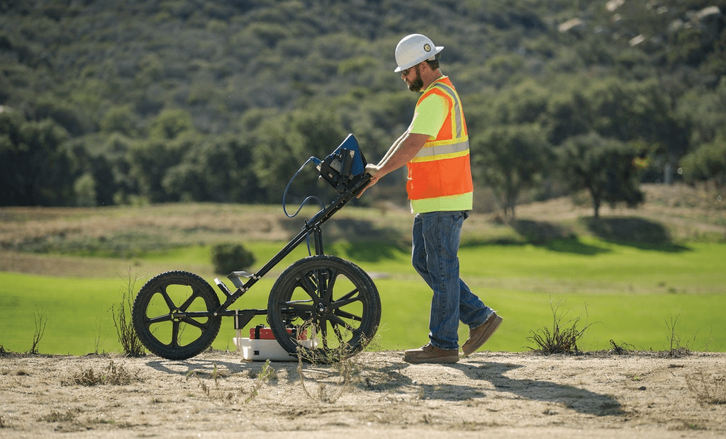
By product mix, cart-based GPR remains the center of gravity and continues to widen its lead, because it best matches the highest-frequency purchasing scenarios: road and airport condition assessment, rebar and cover mapping at scale, and repeatable corridor surveys where productivity and standardized reporting decide the bid. Handheld units remain essential and resilient especially for jobsite verification and confined work but they grow more like a replacement-and-upgrade market anchored on ruggedness and operator experience. Vehicle and towing systems expand steadily because they monetize speed and coverage in transportation and large-area scanning, but they also carry higher deployment friction (calibration discipline, data pipelines, and trained crews), which naturally moderates adoption even when ROI is attractive. In other words, the mix shift is not about bigger is better ; it is about which form factor reduces total survey cost per linear meter while still producing evidence that owners, insurers, and regulators will accept.
Application structure explains the market s durability. The largest revenue pool continues to sit in concrete investigation and adjacent NDT workflows, where GPR is becoming an operational standard for rebar location, thickness estimation, void detection screening, and retrofit risk reduction use cases that directly translate into fewer change orders and fewer safety incidents. Municipal inspection, transportation infrastructure, utility detection, and geology and environment rise in tandem because they share the same pain point: once underground assets are dense and poorly documented, the cost of not knowing dominates the cost of measurement. By contrast, archaeology and pure research are important to credibility and methodology advancement but remain smaller and, in some regions, structurally flat because budgets do not scale with construction intensity. This is why the market feels like a manufacturer-investor forum topic: OEMs see a long runway in workflow embedding and fleet standardization, while buyers see payback through avoided damage, schedule certainty, and defensible documentation rather than through headline performance metrics.
From a manufacturing and value-chain perspective, the competitive boundary is shifting from hardware BOM optimization to system-level reliability and interpretable outputs. Antenna design and RF front-end performance still matter, but differentiation increasingly comes from calibration robustness, environmental stability, EMI/EMC performance, battery/runtime engineering, rugged enclosure design, and most importantly how cleanly the system turns raw traces into actionable deliverables under real field constraints (wet soils, reinforced concrete clutter, operator variability, and noisy RF environments). The OEMs that win tend to behave less like instrument sellers and more like fleet suppliers: they build service capacity, training programs, repeatable QA routines, and software pipelines that reduce the dependence on a single expert operator. That is also where margin and retention live, and it is why the market can grow at a steady mid-single-digit rate without relying on speculative narratives.